Garmin introduces slate of marine products, accessories, services
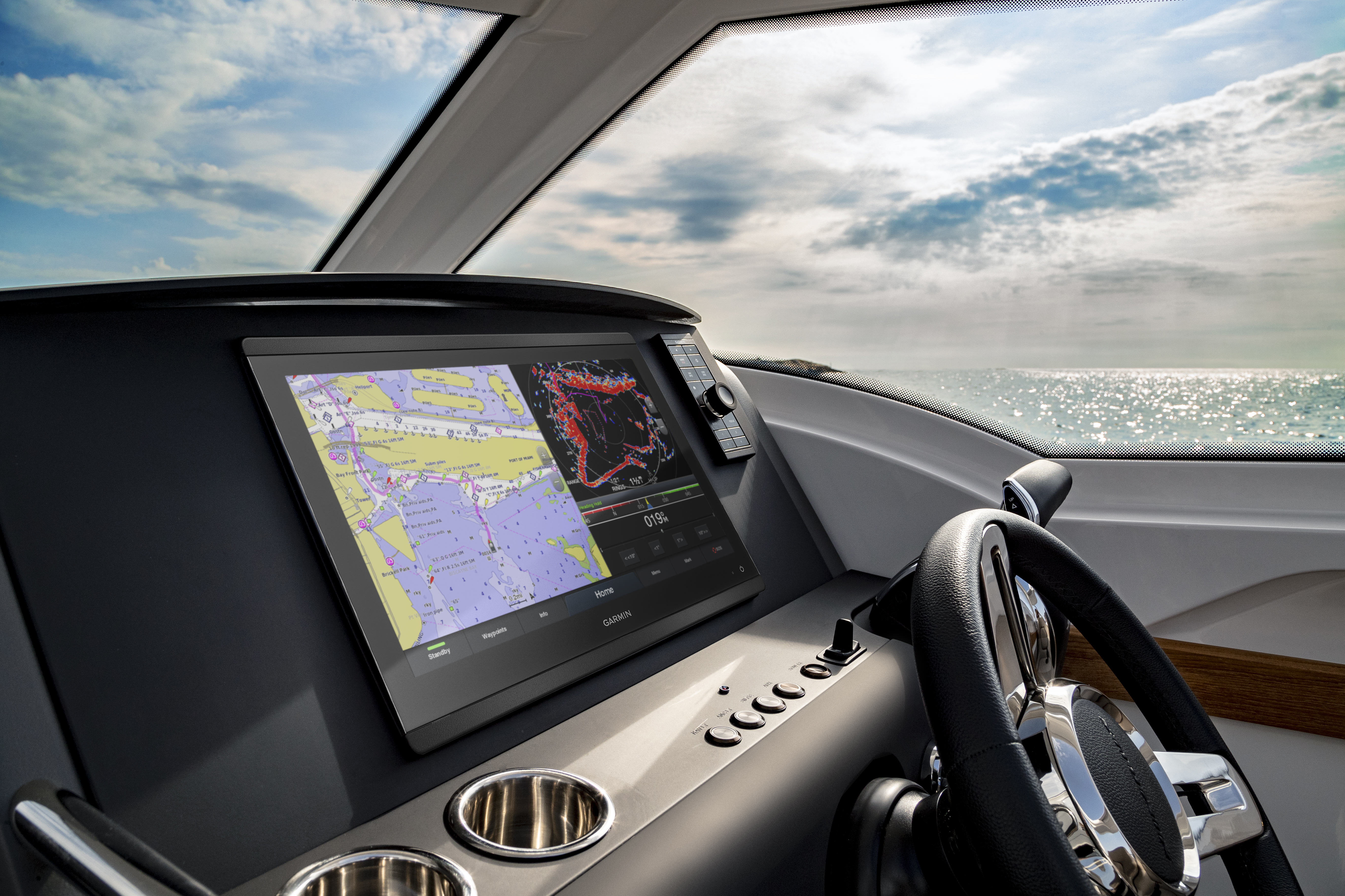
Garmin International, Inc. recently announced BlueChart g3 and LakeVü g3, a new line of cartography products for coastal and inland boating that blend the best of both Garmin and Navionics content together for the first time to deliver unparalleled coverage and detail.
The new BlueChart g3 charts and LakeVü g3 maps will also be the first preloaded cartography to offer built-in Auto Guidance1, a technology that instantly searches through relevant charts to create a suggested route based upon the user’s desired depth and overhead clearance.
“In our pursuit to provide the greatest global cartography offerings, Garmin’s new g3 products combines the best content from both Garmin and Navionics to provide the highest quality detail and coverage available to mariners today,” said Dan Bartel, Garmin worldwide vice president of consumer sales. “And we didn’t stop there—our premium g3 cartography will also include built-in Auto Guidance technology, a feature previously only available with an additional accessory card.”
This new Garmin cartography brings new detail and convenience to users with navigational aids, spot soundings, depth contours, tides and currents, and detailed harbors and marinas. It offers chart presentation with up to 1-foot fishing contours that provide a more accurate depiction of bottom structure for improved fishing charts and enhanced detail in swamps, canals, marinas and port plans.
For even more detail, BlueChart g3 Vision and LakeVü g3 Ultra accessory cards are also available. BlueChart g3 Vision includes everything available with BlueChart g3, plus high-resolution satellite imagery that provides the user with a realistic view of their surroundings. Unique 3-D views, including MarinerEye and FishEye, provide additional perspective both above and below the water line, and crystal-clear aerial photography shows exceptional detail of many ports, harbors and marinas.
The new GPSMAP 8600/8600xsv series, expected to be available in Q1 2019, is the first to come preloaded with Garmin’s exclusive BlueChart g3 coastal charts and LakeVü g3 inland maps with integrated Navionics data and Auto Guidance technology. The new BlueChart g3 and LakeVü g3 downloads and BlueChart g3 Vision and LakeVü g3 Ultra accessory cards will be available in February 2019.
The GPSMAP 8600/8600xsv series is an extension of Garmin’s flagship GPSMAP 8600 series, that brings premium features like built-in sonar and BlueChart g3 coastal cartography and LakeVü g3 maps with Navionics data and built-in Auto Guidance1 to smaller, more affordable display options.
Available in 10-, 12- and 16-inch displays that feature full HD in-plane switching (IPS) screens with multi-touch control, the GPSMAP 8600/8600xsv series is Wi-Fi enabled and offers full connectivity and networkability so mariners can completely customize their marine electronics system based on their needs and preferences.
“Garmin was the first to create a glass-helm design, and we’re excited to bring this stunning appearance to smaller, more affordable displays without compromising the premium performance our customers know and depend on from our award-winning GPSMAP series,” Bartel said. “The GPSMAP 8600/8600xsv series offers unmatched sonar, cartography and connectivity capabilities so fishermen, cruisers and sailors can feel more confident at the helm, and spend more time enjoying their passions on the water.”
The GPSMAP 8600xsv series includes support for dual-channel 1kW traditional CHIRP, CHIRP ClearVü and CHIRP SideVü scanning sonars, plus Ultra High-Definition scanning sonar, giving anglers the greatest sonar detail available from a Garmin system to date. These chartplotters also support the full Garmin Panoptix all-seeing sonar product line, including Panoptix LiveScope, the first and only live real-time scanning sonar available on the market today. Non-sonar capable versions of each new display – the GPSMAP 8610, GPSMAP 8612 and GPSMAP 8616 – are also available.
Garmin also announced three new accessories built with the mariner in mind – the Reactor Autopilot Remote, GRIDTM 20 Remote Input Device and GCTM 200 Marine IP Camera – as part of a new product lineup introduction at the 2018 Fort Lauderdale International Boat Show.
Reactor Autopilot Remote
The rugged, water-resistant Autopilot Remote is the ultimate in onboard control and convenience. Boasting a bright, sunlight-readable color display and an enhanced user experience, the Reactor Autopilot Remote features a comfortable ergonomic design and programmable presets for quick access to your favorite functions. The new Autopilot Remote features gesture controls for heading hold and course corrections; simply point the remote in the desired course direction. The remote is built water-resistant and it floats. The Reactor Autopilot Remote includes a cradle and wrist and neck lanyards and is expected to be available in Q4 2018.
GRID 20 Remote Input Device
The GRID 20 remote input device provides remote access and control of an entire Garmin marine system. It features a 360-degree joystick with a rotary knob and push-to-select button for chartplotter menu/setting navigation and fine control. Users can designate four favorite keys to restore their system to a previously saved configuration. There are also a variety of hard keys for quick access to important functions, including left and right screen switches, autopilot standby/engage and more. There’s also a dedicated SOS key. The GRID 20 can be wired via NMEA 2000 or the included power cable, or installed wirelessly. This plug-and-play solution can be tailored to a user’s system preference with both vertical and horizonal mounting options, and its small footprint makes it convenient to integrate into a busy helm or between two displays. The GRID 20 is expected to be available in Q4 2018.
GC 200 Marine IP Camera
Designed to provide users added security onboard their vessel, the GC 200 IP Camera allows mariners to monitor areas above and below deck in clear, real-time HD video – even in low light. Up to four cameras can be streamed at a time on a single chartplotter, or shared across multiple compatible chartplotters on the Garmin Marine Network. The GC 200 IP Camera features a reverse-image setting on compatible chartplotters, which allows for flexible installation at any angle, including upside down as a back-up camera. The GC 200 IP Camera can be mounted in virtually any orientation, because its images can rotate 90/180/270 degrees, and it comes with a rugged, water-resistant case, so users can place it nearly anywhere they need a camera. The GC 200 IP Camera is expected to be available in Q4 2018.
Lastly, Garmin announced the inReach Mini Marine Bundle, a new addition to its line of satellite communicators with available two-way messaging, basic navigation and a 24/7 SOS function via the global Iridium network1 built with the mariner in mind.
Designed for life on the water, the inReach Mini Marine Bundle includes a rugged mount and 12-volt power cable that provides added peace of mind, especially in the event of power loss on the vessel, without taking up space at the helm. To access the Iridium network and communicate with an inReach Mini device, an active satellite subscription is required. A variety of subscription plans are available for both individuals and groups/fleets, and mariners will appreciate the flexible month-to-month options that can be suspended in the offseason if desired.
The inReach Mini wirelessly connects with compatible Garmin chartplotters, handhelds and wearables, and works anywhere when using the Iridium satellite network.
“The inReach Mini is your go-to connection for maintaining off-the-grid contact while giving you – and your friends and family onshore – extra peace of mind on the water,” Bartel said. “Whether it’s to say that the bite is hot and you’ll be home late, or to check in with loved ones while you’re sailing to Hawaii or worst case, to report an emergency onboard, the inReach Mini lets you send and receive messages, track and share your journey, and if necessary, trigger an SOS.”
The Earthmate app easily pairs with the inReach Mini via Bluetooth to a compatible smartphone for access to unlimited maps, aerial imagery, and U.S. NOAA charts. The Earthmate app also allows all of the inReach features to be accessed through the paired mobile device, including location tracking, so a user can share their whereabouts with anyone in their contact list. The app will seamlessly allow the user to access their compatible device’s contact list for quick access without manual entry.
Built to withstand extreme conditions, the inReach Mini is impact resistant and water-rated to IPX73. The inReach Mini Marine Bundle includes an internal, rechargeable lithium battery for up to 50 hours of use at the default 10-minute tracking mode and up to 20 days at the 30-minute interval extended tracking mode. It also includes a marine mount and hardware, 12-volt power cable and flotation lanyard. Expected to be available in Q1 2019.
All of Garmin’s new products will be on display at the Fort Lauderdale International Boat Show in the electronics tent at booth No. 332.